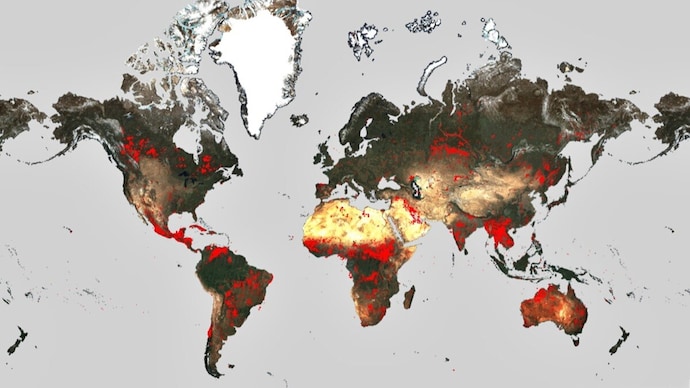
World Fire Atlas shows wildfires raging across the planet
The surge in wildfires is attributed to rising global temperatures and an increase in extreme weather events, leading to rapid consumption of vast areas of vegetation and forested lands.

In Short
- Wildfires are becoming increasingly frequent and widespread
- European Space Agency (ESA) has upgraded its World Fire Atlas
- Over 234,516 hectares of land across the European Union have already been burned
Maui's wildfires have killed at least 55 people, a toll expected to rise, and unleashed destruction on the resort town of Lahaina that will take many years and billions of dollars to rebuild, Hawaiian officials said.
Wildfires are becoming increasingly frequent and widespread, causing significant human casualties and extensive environmental and economic damage.
Countries such as Greece, Italy, Spain, Portugal, Algeria, Tunisia, and Canada have been particularly affected in recent weeks.
In response to this escalating crisis, the European Space Agency (ESA) has upgraded its World Fire Atlas, providing a detailed global analysis of wildfires.
The surge in wildfires is attributed to rising global temperatures and an increase in extreme weather events, leading to rapid consumption of vast areas of vegetation and forested lands.
The European Forest Fire Information System (EFFIS) reported that over 234,516 hectares of land across the European Union have already been burned this year alone, as of July 29, 2023.
The World Fire Atlas, reopened by ESA due to the severity of the wildfires, offers insights into the distribution of individual fires at both national and global scales. Its interactive dashboard allows users to compare fire frequencies between countries and analyze the evolution of each wildfire over time.
The atlas uses night-time data from the Sea and Land Surface Temperature Radiometer (SLSTR) on the Copernicus Sentinel-3A satellite to detect fires.
Data from the World Fire Atlas over the past seven years reveals a substantial number of fires detected in Portugal, Italy, Greece, France, and Spain. Canada, currently battling its worst wildfire season on record, has seen a staggering 705% increase in fires during the first seven months of 2023 compared to the same period over the previous six years.
Olivier Arino from ESA stated, "The relaunch of the World Fire Atlas presents a valuable opportunity for authorities, researchers, and organizations to enhance their understanding of fire occurrences worldwide. By utilizing this comprehensive resource, they can devise more effective strategies for fire prevention and management on a global scale."
The commitment of ESA, Copernicus, and the EU to continuously provide this valuable resource underscores the importance of leveraging space technology to address critical environmental challenges.

